


وصف لـ ISS Transit Prediction Free
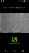
This application generates International Space Station (ISS) Transit Predictions for the Sun, Moon and Planets.
The user specifies a location, which includes latitude, longitude and elevation. The application downloads the latest orbital information (Two Line Elements or TLEs). The application generates a transit prediction map which contains prediction paths for each transit within a specified alert radius.
Pro Version Only: Specify and save multiple locations, Save multiple prediction maps for later viewing, add transit to Calendar, View maps with Google Earth, User specified Two Line Elements. No Ads.
USER INTERFACE
The main screen provides 4 buttons:
•Location - Press this button to add or select the prediction generation location
•Two Line Elements (TLE) - Press this button to download TLEs
•Generate Prediction - Press this button to start the prediction generation
•View Prediction - Press this button to view the prediction map or text file
The options menu provides the following:
•Locations - Press to add, select, edit or delete saved locations (Pro Version Only)
•Predictions - Press to view, share or delete saved prediction maps (Pro Version Only)
•Settings - Press to set user preferences
•DEM Files - Press to list or delete the downloaded DEM Data
•Help - Press to display this help page
•About - Press to display application version, credits and links
LOCATIONS
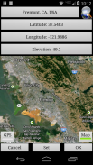
Add a named observing location by clicking the "Location" button accessible from the main screen.
The location coordinates can be entered in any of three methods:
•Manually - Enter latitude, longitude and elevation in the text boxes. Positive values represent North and East, negative values South and West. Elevation can be entered in meters or feet above sea level depending on the current prediction units setting. As the coordinates are typed, the map pans to the location. Press the search button to search for a location.
•Map Input - Use the map to zoom and pan to a location. Pressing the Set button sets the location name, coordinates and elevation in the text boxes. The elevation of the current coordinates is retrieved using the specified elevation data source setting. Switch between map and satellite modes by toggling the Map/Sat button.
•GPS - By pressing the GPS button, the application uses GPS to obtain location coordinates and elevation.
Use the locations page accessible from the options menu to edit and delete saved locations.
GENERATING PREDICTIONS
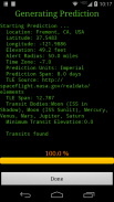
Once a location has been entered and TLE have been downloaded, press the "Generate Prediction" button to begin prediction generation. The progress bar gives an indication of how long it will take to complete the process. Depending on your CPU speed, it can take a few minutes to generate the predictions. Pressing the cancel button will cancel the prediction.
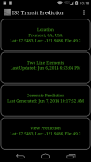
VIEWING PREDICTIONS
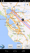
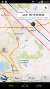
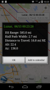
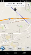
Once the prediction generation is complete, the prediction map or text file can be viewed. Pressing the View Prediction button brings up the previously generated prediction map. The text button within the map view displays the prediction text. The Map/Sat button switches between Map mode and Satellite mode.
Within the map view press the Google Earth button to view the map in Google Earth (Pro Version Only). Press the save button to save the prediction for later viewing (Pro Version Only).
Use the predictions page accessible from the options menu to view, share and delete previously saved prediction maps (Pro Version Only).
PERMISSIONS
Storage: To store/delete elevation data needed for prediction generation as requested by user
System Tools: To prevent device from sleeping during prediction generation
Network Communications: To download ISS orbital elements from the internet
Your Location: Fine (GPS) location. To obtain your current location if requested by user
Your Accounts: Read Google service configuration. To display predictions using Google Maps (Required by Google)
هذا التطبيق يولد محطة الفضاء الدولية (اي اس اس) توقعات العابر للشمس والقمر والكواكب.
يحدد المستخدم موقع، والذي يتضمن خطوط الطول والعرض والارتفاع. التطبيق بتحميل أحدث المعلومات المدارية (اثنان عناصر الخط أو عدوليس). تطبيق يولد خريطة العبور التنبؤ الذي يحتوي على مسارات التنبؤ لكل العابر داخل دائرة نصف قطرها التنبيه المحدد.
الإصدار المحترف فقط: تحديد وحفظ مواقع متعددة، ووفر خرائط التنبؤ متعددة لمشاهدتها لاحقا، إضافة إلى التقويم العبور، عرض خرائط مع برنامج Google Earth، العضو المحدد اثنين من عناصر الخط. لا إعلانات.
واجهة المستخدم
توفر الشاشة الرئيسية 4 أزرار:
• الموقع - اضغط على هذا الزر لإضافة أو حدد موقع جيل التنبؤ
• اثنان من عناصر الخط (TLE) - اضغط على هذا الزر لتحميل عدوليس
• توليد تنبؤ - اضغط على هذا الزر لبدء الجيل التنبؤ
• مشاهدة تنبؤ - اضغط على هذا الزر لعرض خريطة التنبؤ أو ملف نصي
يوفر قائمة الخيارات ما يلي:
• مواقع - اضغط على لإضافة أو تحديدها أو تحريرها أو حذفها الأماكن المحفوظة (الإصدار المحترف فقط)
• التوقعات - اضغط لمشاهدة، حصة أو حذف خرائط التنبؤ حفظ (الإصدار المحترف فقط)
• إعدادات - اضغط لضبط تفضيلات المستخدم
• ملفات DEM - اضغط لسرد أو حذف البيانات ماركا تحميلها
• مساعدة - اضغط لعرض هذه الصفحة مساعدة
• معلومات - اضغط لعرض إصدار التطبيق والاعتمادات والارتباطات
LOCATIONS
إضافة موقع مراقبة يدعى بالنقر على زر "الموقع" يمكن الوصول إليها من الشاشة الرئيسية.
إحداثيات الموقع يمكن إدخالها في أي من ثلاث طرق:
• يدويا - أدخل خطوط الطول والعرض والارتفاع في مربعات النص. تمثل القيم الإيجابية الشمالية والشرق، والقيم السلبية الجنوبية والغربية. الارتفاع يمكن إدخالها في متر أو قدم فوق مستوى سطح البحر بالاعتماد على إعداد وحدات التنبؤ الحالية. كما يتم كتابتها الإحداثيات، والخريطة المقالي إلى الموقع. اضغط على زر البحث للبحث عن مكان.
• خريطة الإدخال - استخدام الخريطة لتكبير وتحريك إلى موقع. الضغط على زر تعيين تعيين اسم الموقع، الإحداثيات والارتفاع في مربعات النص. يتم استرداد الارتفاع من الإحداثيات الحالية باستخدام إعداد مصدر بيانات الارتفاع المحدد. التبديل بين الخريطة وسائط الأقمار الصناعية عن طريق تبديل على زر خريطة / السبت.
• GPS - عن طريق الضغط على زر GPS، يستخدم التطبيق نظام تحديد المواقع للحصول على إحداثيات الموقع والارتفاع.
استخدام صفحة مواقع يمكن الوصول إليها من قائمة الخيارات لتعديل وحذف المواقع المحفوظة.
PREDICTIONS توليد
مرة واحدة وقد دخلت الموقع وTLE تم تحميلها، اضغط على الزر "إنشاء تنبؤ" لبدء توليد التنبؤ. يعطي شريط تقدم مؤشرا على مدى فترة طويلة من الوقت سيستغرق لإتمام العملية. اعتمادا على سرعة وحدة المعالجة المركزية الخاصة بك، يمكن أن يستغرق بضع دقائق لتوليد التنبؤات. والضغط على زر إلغاء إلغاء التنبؤ.
يشاهد PREDICTIONS
مرة واحدة في الجيل التنبؤ اكتمال الخريطة التنبؤ أو ملف نصي يمكن عرضها. الضغط على زر مشاهدة التنبؤ إحضار خريطة التنبؤ إنشاؤه مسبقا. زر النص ضمن عرض الخريطة يعرض النص التنبؤ. مفاتيح زر خريطة / السبت بين وضع خريطة ووضع القمر الصناعي.
في الصحافة عرض خريطة الزر Google Earth لعرض الخريطة في برنامج Google Earth (الإصدار المحترف فقط). اضغط على زر حفظ لحفظ التنبؤ لمشاهدتها لاحقا (الإصدار المحترف فقط).
استخدام صفحة التنبؤات يمكن الوصول إليها من قائمة الخيارات لعرض وتبادل وحذف خرائط التنبؤ المحفوظة مسبقا (الإصدار المحترف فقط).
PERMISSIONS
التخزين: لتخزين / حذف البيانات اللازمة لتوليد الارتفاع التنبؤ على النحو المطلوب من قبل المستخدم
أدوات النظام: لمنع الجهاز من النوم خلال جيل التنبؤ
شبكة الاتصالات: لتحميل ISS العناصر المدارية من الانترنت
الموقع الخاص: الجميلة (GPS) موقع. للحصول على موقعك الحالي إذا طلبه من قبل المستخدم
الحسابات الخاصة بك: اقرأ تكوين خدمة جوجل. لعرض التنبؤات باستخدام خرائط جوجل (المطلوبة من قبل جوجل)
ISS Transit Prediction Free - إصدار 3.0.8
(21-12-2023)ISS Transit Prediction Free - معلومات APK
نُسخة APK: 3.0.8الحزمة: com.ed_morana.iss_transit_prediction_freeتطبيقات من الفئة نفسها
قد يعجبك أيضًا...


